|
The Meridian Line - Sunday 08.06.2025
"Believe you can and you're halfway there." – Theodore Roosevelt
|
|
|
The Grampians (Gariwerd) Touring Map – from $14.95
Discover the Grampians like never before with Meridian Maps' detailed 1:100,000 scale map. Designed for 4WD adventurers, road trippers, and holidaymakers alike, this map highlights the region’s rich variety of attractions and outdoor experiences. Follow the Grampians Way Touring Route, uncover public Indigenous art sites, explore local wineries, and find the best rock climbing areas, campgrounds, fishing spots, hiking trails, and picnic grounds—all clearly marked for easy navigation. With detailed coverage of the extensive walking trail network, including the iconic Grampians Peaks Trail, this map is the perfect companion for anyone wanting to immerse themselves in the natural beauty and adventure of the Grampians region.
https://meridianmaps.com.au/product/the-grampians-touring-map/
Tanami Road – from $14.95
The Tanami Track offers one of the most remote and rewarding routes through the Australian outback, providing the most direct overland connection from the southern states to the Kimberley via Alice Springs. This vast and often unforgiving landscape introduces travellers to the stark beauty and immense scale of Australia’s arid heartlands. Westprint’s Tanami Track Heritage Map brings this iconic route to life, charting its rich gold rush history and the early stock routes that demanded extraordinary endurance and resilience. While the route is gradually being upgraded, it remains a remote and potentially hazardous journey—one that demands preparation and respect. Renowned for their desert maps, Westprint delivers a comprehensive and easy to read guide, complete with historical notes, details on explorers, natural features, and insights into local flora and fauna. The map includes road distances, rest areas, fuel stops, caravan parks, and GPS coordinates with a clear Lat/Long grid—everything needed to travel this extraordinary track with confidence and curiosity.
https://meridianmaps.com.au/product/tanami-road/
Cobaw Ranges Lancefield Forest Activities Map – $6.95
Explore Cobaw State Forest with Rooftop’s durable and detailed map, scaled at 1:50,000. Covering the forest region northwest of Lancefield, this pocket-sized map is perfect for motorbike riders and 4WD adventurers. Printed on waterproof and tear-resistant material, it’s built to withstand tough conditions—making it an essential companion for off road exploration.
https://meridianmaps.com.au/product/cobaw-ranges-map/
Best Walks of South West WA - $32.95
The South West of Western Australia is a walker’s paradise—renowned as one of the premier hiking destinations in the state. This brand-new addition to Australia’s bestselling walking guide series features 40 carefully selected walks, along with variations to suit different interests and abilities. From easy coastal strolls to forested waterfall trails and more rugged adventures deep within the region’s iconic national parks, there’s something for every type of walker. Clear, detailed maps and comprehensive track notes guide you through the region’s breathtaking forests, rivers, and coastlines. The guide is beautifully illustrated with over 200 full-colour photographs and includes dozens of maps to enhance your experience. A handy summary table helps you quickly compare walks by distance, difficulty, highlights, and nearby cafés. Covering both the world-famous Margaret River and Capes regions, as well as the expansive Southern Forests, this guide uncovers hidden gems alongside beloved trails—making it the perfect companion for discovering the natural beauty of WA’s South West.
https://meridianmaps.com.au/product/best-walks-of-sw-wa/
Australian Bush Cooking - $39.95
From roasts and rissoles to salads, savouries, dampers and desserts—Australian Bush Cookingbrings delicious variety to your outdoor meals. Whether you’re cooking over an open fire, using a gas cooker, or preparing meals in your caravan or camper’s kitchen, this book offers simple, satisfying recipes that are easy to make and full of flavour.
Designed for ease and practicality, every recipe uses basic, readily available ingredients and has been thoroughly road-tested by the authors in the great outdoors. Now in full colour, the book features mouth-watering images of the dishes, along with step-by-step illustrations of the techniques and tools used on the road. ButAustralian Bush Cookingis more than just a recipe collection—it’s a comprehensive guide to campfire cuisine. Inside, you’ll find advice on bush cooking equipment, tips for menu planning, guidance on building the perfect cooking fire, and even how to master the art of making a proper cup of billy tea. Whether you're a seasoned traveller or a first-time camper, this book will become your trusted companion for cooking under the stars.
https://meridianmaps.com.au/product/australian-bush-cooking/
Meridian Musings
Thank you so much to those who sent us such lovely messages on the birth of our granddaughter. They were truly appreciated, and it has been a joy watching our daughter become a parent and having this new little being in our lives.
It’s the King’s Birthday long weekend coming up soon and a good excuse to get out and about! The long weekend means the official beginning of the ski season and many seasonal road closures. Please remember to check for any closures and take care with any challenging road conditions as well as road closures.
What’s New to the Website
|
|
|
|
Hattah-Kulkyne Map Guide – from $11.95.
This third edition of the Hattah-Kulkyne Map Guide has just arrived from the printers. This newly updated map features an enlarged scale of 1:70,000, providing greater detail and clarity. It includes updated field notes, information on facilities, and the latest track data, along with a brand-new map covering the area from Lake Hattah to Lake Mournpall. As the only map available that covers the entire park, it offers both comprehensive coverage and valuable insights. The map is double-sided, featuring informative text as well as historical and tourist information, and is presented in a new, larger flat size of 600mm by 500mm.
https://meridianmaps.com.au/product/hattah-kulkyne-map-guide/
Please note that we have updated the payment screen to read Credit Card / Debit Card to indicate that payment can pay by either card type with that button.
|
|
|
|
Seasonal Updates
Please be aware that road and Park closures are constantly changing and it is always best to check for changes before you set out.
For more regular updates on closures, please check our Facebook page athttps://www.facebook.com/MeridianWestprintMapsas we try to include warnings and advice as we become aware of them.
The latest Desert Parks Bulletin has been uploaded to our website. For this and other Desert Pass updates, please go tohttps://meridianmaps.com.au/deserts-pass-update/3
In Victoria, seasonal road closures generally operate from after the King's Birthday long weekend in June through to the end of October, but the closures may be extended if conditions are not suitable to safely re-open the roads. For a full list of all 2025 closures, please refer to the Parks Vic websitehttps://www.parks.vic.gov.au/get-into-nature/safety-in-nature/seasonal-road-closures.
Innamincka Regional Reserve and Malkumba-Coongie Lakes National Park — Closed Due toFlooding
Witjira National Park — Closed Due toRain
Munga-Thirri – SimpsonDesert NationalPark - partialclosuredue to rain.
- Colson Track –Closed due toflooding.
- Public Access Route 15K1Warburton Crossing–Closed due to flooding.
The Waranga Rail Trail in Victoria, between Rushworth and Murchison, officially opened on May 17.
Many roads, fire trails and walking tracks in Blue Mountains National Park are closed due to infrastructure upgrades or damage caused by wet weather including subsidence, rockfalls, landslides and fallen trees.https://www.nationalparks.nsw.gov.au/alerts/alerts-list
Disclaimer: These events were correct at the time they were added to the Meridian Line; however, this may have been some time before the actual event. Please make your own enquiries before travelling to an event.
What’s On
14 June: Walgett Racein NSW. Activities for everyone including party marquees, jumping castles, food stalls, novelty races, live music and a bar.
https://www.walgettraces.com.au/
29 – 23 June: Alice Springs Beanie Festival Incin Northern Territory. Since 1997, this event has grown from a ‘beanie party’ into a celebration of culture, art, and storytelling. It brings together artists from remote Aboriginal communities and visitors from all over the country to showcase thousands of creative, handcrafted beanies.
https://www.beaniefest.org/
27 – 28 June: Pine Creek Gold Rush Festivalin Northern Territory. Celebrates the history of Gold Mining in the region with a competition for the Northern Territory Gold Panning Championship. The Festival is an opportunity for the local population to showcase their town and its rich mining history.
https://northernterritory.com/katherine-and-surrounds/events/pine-creek-gold-rush-festival
5 July: Jundah Camel Racesin Queensland. Races and camel antics, and a fantastic atmosphere. Watch the camels gallop down the track with their humps bouncing in rhythm.
https://www.outbackqueensland.com.au/event/jundah-camel-races/
7 – 13 July: Brewarrina Blizzardin NSW. Transforming the remote community into a winter wonderland with a full-sized ice rink, snow experience, food vendors and more, and all completely free.
https://brewarrina.nsw.gov.au/brewarrina-blizzard/
8 – 10 July: Birdsville Camel Carnivalin Queensland. Inaugural event that part of a larger Outback Camel Trail. Includes concerts, camel rides and cameleer history, pig races, and Queensland artisan markets.
https://www.outbackqueensland.com.au/event/birdsville-camel-carnival/
12 July: Bedourie Camel & Pig Racesin Queensland. Camel racing and the pig racing including novelty events, market stalls and a golf “Closest to the Pin” competition and entertainment.
https://www.outbackqueensland.com.au/event/bedourie-camel-pig-races-2025/
Do you have a story?
If you’ve got a trip or tips to share, we’d love to hear from you -rochelle@meridianmaps.com.au.
Multi day hikes – New South Wales
|
|
|
|
New South Wales is a hiker’s paradise, offering a stunning variety of landscapes—from rugged coastlines and lush rainforests to dramatic mountain ranges and remote outback terrain. For those seeking the challenge and adventure of multi-day hikes, NSW is home to some of the most rewarding and unforgettable trails in Australia.
The Great North Walk
|
|
|
|
Distance:260 km (approximately 16 days)
Difficulty:Moderate to challenging
Highlights:In the early 1980s, Garry McDougall and Leigh Shearer-Heriot spent weekends exploring the bushland between Sydney and Newcastle, driven by a vision to create a continuous walking track linking the two cities. By 1986, their idea gained formal support and funding from the NSW Bicentennial Council, with the NSW Lands Department stepping in to manage the project and provide much of the necessary funding. In 1987, the name "Great North Walk" was chosen, inspired by the convict-built Great North Road (1826–1836), which originally connected Sydney to Newcastle. The walk officially opened in 1988 as part of Australia’s Bicentennial celebrations.
|
|
|
|
The Great North Walk is a breathtaking 260 kilometre trail that links Sydney to Newcastle, guiding hikers through some of New South Wales' most beautiful and diverse landscapes. Following historical routes—including sections of the original Great North Road—the trail winds through lush bushland, scenic river valleys, and vibrant national parks. Whether tackling the entire journey or exploring shorter sections, the Great North Walk offers a mix of challenging climbs, peaceful paths, and opportunities for camping under the stars. It’s the perfect adventure for anyone seeking natural beauty along with a deeper connection to Australia’s rich cultural and historical heritage.
The walk begins at Macquarie Place in central Sydney, with a short stroll leading to the first water section: a ferry ride from Circular Quay. From there, the southern sections of the trail pass heritage homes and historic sites in Sydney’s suburbs before entering Lane Cove River National Park. The trail then follows the river north to Thornleigh, continuing along Berowra Creek and through parts of Ku-ring-gai Chase National Park, eventually reaching Brooklyn on the Hawkesbury River.
|
|
|
|
Beyond the Hawkesbury, the trail winds through Brisbane Water National Park, the Ourimbah Valley, and the Watagans National Park. The route turns near Congewai, about 10 kilometres south of Millfield, and then follows the Myall Range to Teralba. The trail then crosses the Five Islands Bridge, skirts the northern edge of Lake Macquarie, and curves around the bay before reaching the southern suburbs of Newcastle. The walk concludes at Queen’s Wharf in central Newcastle, near the main railway station.
|
|
|
|
The Great North Walk can be enjoyed in its entirety or broken into shorter hikes. The trail is divided into manageable sections, making it ideal for both day walks and shorter multi-day adventures. Each section offers its own unique scenery—from river valleys and coastal outlooks to rugged bushland and protected national parks.
Accommodation options along the trail are plentiful, ranging from campsites to hostels, motels, and private rentals. Many accommodation providers offer transport to and from specific access points along the walk. For those camping, some hikers organise food and water drops or use local shops along the way to keep pack weights manageable.
Light to Light Walk
|
|
|
|
Distance:30 kilometres one way (2–3 days)
Difficulty:Moderate
Highlights:The Light to Light Walk is a spectacular 30 kilometre coastal hike in Beowa National Park (formerly Ben Boyd National Park), located on the Sapphire Coast of New South Wales.
|
|
|
|
|
|
|
This scenic trail runs from Boyd’s Tower near Eden to the Green Cape Lighthouse, offering sweeping views of rugged cliffs, pristine beaches, and the open ocean. Named after the two historic lighthouses that bookend the walk—both built to help ships navigate the treacherous Bass Strait—the trail winds through a rich and varied landscape of heathland, coastal forest, and secluded coves.
|
|
|
|
|
|
Wildlife encounters are common along the way, with the chance to spot dolphins, seals, and a wide variety of bird species. The walk typically takes 2 to 3 days to complete, with several campsites and accommodation options along the route.
|
|
|
|
Upgrades to the Light to Light Walk in Beowa National Park have been completed and the trail has reopened to the public. This revitalised multi-day walk was part of a $14.9 million revitalisation project in the national park. It commenced in March 2023 and spanned the full length of the track from Boyds Tower to Green Cape Lighthouse. The upgrade includes new and re-routed sections of the trail, designed to improve walker experience and safety, while minimising environmental impact.
Two purpose-built campgrounds were added at Mowarry Point and Hegartys Bay, each featuring 10 new timber camping platforms and toilets, providing convenient overnight options along the upgraded route. The project also included essential bushfire recovery work following the 2019/2020 fires, with repairs to damaged track sections and upgrades to key visitor areas.
|
|
|
|
The Light to Light Walk can be enjoyed as a full multi-day hike or explored in shorter day-walk sections, making it accessible for a range of fitness levels and timeframes. Facilities are available at both Saltwater Creek and Bittangabee Bay campgrounds, including picnic tables, barbecues, and toilets. Hikers will need to bring their own tents and supplies. Additional accommodation is available at the Green Cape Light station Keepers' Cottage, although it will be closed until September 2025.
Green Gully Track
|
|
|
|
Distance:65 kilometres loop (4 days)
Difficulty:Moderate
Highlights:The Green Gully Track is a 65 kilometre hike in in the south eastern corner of World Heritage-listed Oxley Wild Rivers National Park. This remarkable trail heads into the Apsley-Macleay gorges, one of Australia’s largest gorge systems, renowned for its dramatic landscapes and rich biodiversity.
|
|
|
|
Over four days, the track guides hikers through an incredible variety of terrain, including fern-lined gullies, pristine mountain streams, high-elevation forests, and rugged rocky outcrops. The scenery is matched by the abundance of wildlife, offering chances to spot brush-tailed rock wallabies, swamp wallabies, possums, wedge-tailed eagles soaring overhead, and even native marsupial mice.
|
|
|
|
The journey begins and ends at Cedar Creek Cottage, with each day offering new challenges and highlights. On the third day, hikers descend into Green Gully itself, following the course of a creek for more than 10 kilometres, including sections where walkers wade directly through the creek.
|
|
|
|
The Green Gully Track allows a maximum of six people per group, all participants must be over 12 years olds and solo hikers cannot book the trail. This limit is in place to ensure the huts and facilities are not overcrowded and to minimize the environmental impact on the trail. Each group has exclusive use of the huts during their hike, making it a more private and comfortable experience. Each hut is fitted with beds or camping stretchers, rainwater, solar-lighting, non-flush toilets, and basic cooking equipment.
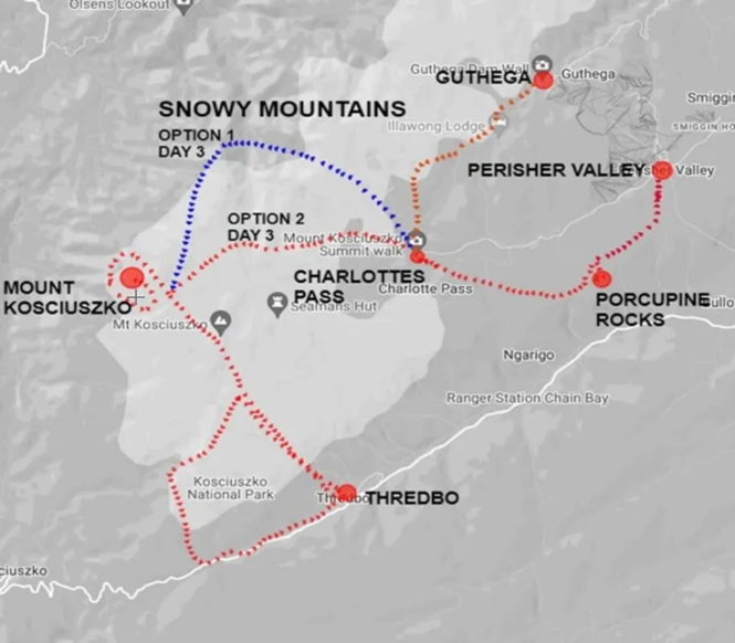
Snowies Alpine Walk
|
 |
|
Distance:56 kilometres one way (4 days)
Difficulty:Moderate
Highlights:The Snowies Alpine Walk is a 56 kilometre multi day hiking trail in Kosciuszko National Park, with the full route officially opened in December 2024. Connecting the alpine villages of Guthega, Perisher Valley, and Charlotte Pass, the trail incorporates 27 kilometres of new walking track, seamlessly linking existing routes. Walkers can choose to explore single day sections or combine them into a multi day alpine adventure.
|
|
|
|
The walk offers a spectacular alpine experience, winding through the Snowy Mountains and following the Snowy River as it climbs towards some of the region’s highest peaks, including Mount Kosciuszko, Australia’s tallest mountain. Along the way, hikers are immersed in a diverse landscape of majestic snow gum forests, wildflower-filled meadows, glacial lakes, and rugged rocky outcrops. Wildlife sightings are common, with kangaroos, wombats, and various native bird species often spotted along the trail.
|
|
|
|
Winding through the Snowy Mountains and theKosciuszko National Parkfor, the route takes hikers along the banks of the Snowy River and up several of the region’s highest peaks, including Mount Kosciuszko – the tallest peak in Australia. Starting in Guthega, the route takes in Charlotte Pass, Perisher and Bullocks Flat – meandering along stunning mountain ledges and through thick forests of majestic snow gum, wildflower-filled meadows, glacial lakes, rugged rocky outcrops, and snow gum forests.
|
|
|
|
According to NSW National Parks and Wildlife, the Snowies Alpine Walk is generally completed over four days. The first day covers the 9 kilometre stretch from Guthega to Charlotte Pass, a section that passes through Monero Ngarigo Country. The second day is the most challenging, following a 22 kilometre route that climbs up Main Ridge. On day three a 12.9 kilometres walk to Perisher is completed and the final leg is an 11 kilometre hike from Perisher to Bullocks Flat.
|
|
|
|
A range of accommodation options are available for hikers, including Numbananga Lodge, Creel Lodge, and Creel Bay Cottages, managed by NSW National Parks and Wildlife Service. Additional lodging can be found in nearby alpine villages such as Jindabyne, Thredbo, Perisher, Guthega, and Charlotte Pass. Transport to and from the trailheads must be arranged in advance, particularly for those not based in the area.
The Snowies Alpine Walk is not suitable for hiking during the winter months, as snow covers much of the track and conditions can become dangerous. Hikers are encouraged to plan their trip during the warmer months when the full beauty of the alpine region is on display.
Meridian Mirth
To share your jokes, please send them torochelle@meridianmaps.com.au.Thanks to Paul and Simon for sending in these jokes!
Another version of'The Man from Snowy River.'
There was trouble at the station, for the word had got around,
That the Kitchen maid was pregnant and the culprit must be found.
Was it Harrison or Clancy, or perhaps the Chinese cook,
Whose defence I give verbatim: “Me do nothing, me just look!”
Early betting was on Harrison, although his hair was white,
For the country folk will tell you, that a grizzled dog can bite.
And Clancy of the Overflow, came in for mention too,
As the speculation mounted, and the accusations flew.
Till the Boss’s wife grew angry, and at last was moved to state,
There’s a resolution coming, I’d advise you all to wait.
When the maid’s child is delivered - and the day is surely nigh,
Then the issue will be settled, and we’ll see just who he’s by!
We will study frame and visage, and we’ll know without a doubt,
Whether station sire or stranger, for the truth will surely out.
We are practiced in such matters, whether human, dog, or horse,
So just cease these allegations and let nature take its course.
And take its course, it surely did, the maid confined to bed,
Produced a healthy baby boy, just as the Missus said,
And close perusal of the lad, the strangest thing revealed,
His sire was never in the call - the roughie of the field!
The steel-blue eyes, the sandy hair, the legs already bent,
The rattle flourished like a whip, the clearest message sent.
And Clancy of the overflow, these features pointed out,
Till all agreed the culprit was, that bloody rouseabout!
He came from mountain country, up by Kosciusko’s side,
A skinny sawn-off little sod, one clearly born to ride.
In fact, he rode before he walked, he knew no other trade,
And so it was, this Snowy lad, had saddled up the maid!
And round the campfire every night, the ringers wondered why,
This Snowy River specimen, had caught the maiden’s eye,
And jubilation and regret, in equal measure weighed,
With those who’d tried and failed to win, the little Kitchen maid.
Nothing as good as Aussie Bush Poetry (with apologies to Banjo Paterson)
|
 |
 |
 |
|
The Fine Print
At The Meridian Line
Wherever possible we try to acknowledge the source of all information contained in this newsletter. We offer no guarantees for accuracy, but we do our best.
Get the Word Out
Feel free to forward this newsletter to any family or friends who you feel might enjoy a good read. If they would like to receive this newsletter on a regular basis they can register at:https://meridianmaps.com.au/newsletter/
Using information from this newsletter
You are welcome to use information from this newsletter, but we request that you kindly acknowledge that the information is from The Meridian Line.
Meridian Contact information
Email:rochelle@meridianmaps.com.au
Newsletter Email Address
Please do not reply tonewsletter@meridianmaps.net.au. This email is not monitored. Please contactrochelle@meridianmaps.com.au
Disclaimer
Please note that the opinions and articles expressed in The Meridian Line are not necessarily those of The Meridian team. Also, we do not endorse any products (other than our own), or tours listed in my contributed articles.
|
|
|
|
|